


Flooding on the Brahmaputra has brought death, displacement and disease to what has become one of India's poorest regions
Kieran Cooke in Laupani, India
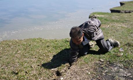
Flood of misery … the
overflowing waters of the Brahmaputra river have encroached on the land
of locals, heaping sand on their paddy fields. Photograph: Kieran Cooke
"When I came to the village to marry, 42 years ago, it took an hour to walk to the river," says Bhujel.
"Now the river's waters are here, eating away at our land, heaping sand on our paddy fields."
The Brahmaputra is one of the world's mightiest rivers, 10km wide in places. Its waters rise more than 5,000 metres up the Tibetan Plateau and flow for about 3,000km through China, India and Bangladesh before joining the Ganges and emptying into the Bay of Bengal.
The river is a lifeline to millions, delivering vital nutrients to the plains of Assam and other areas, but its fast flowing waters also cause widespread misery. In 2012, more than 1.5 million people in Assam were displaced by floods, with many lives lost and whole villages washed away.
Bhujel is 70. Her calloused hands and lined face are testament to a lifetime of hard work on the land. She is dressed in a widow's white sari: her husband died last year.
"We once had three bighas of land [one bigha is about a third of an acre], but most of it has been eaten away by the river. The last thing my husband did before he died was sell our cattle."
In part the flooding and land erosion is a natural phenomenon. The Brahmaputra carries a vast volume of water, an amount only exceeded by the Amazon and Congo rivers.
As the Brahmaputra's waters cascade down from the mountains on to the soft alluvial soils of Assam, they eat away at the river's banks and deposit tons of sand on nearby lands, turning once verdant areas into what looks like an enormous beach.
North-eastern India is a highly seismic zone. An earthquake in 1950 was one of the most violent recorded, altering the geology of the entire Brahmaputra river basin and raising the river level by eight to 10 metres in places.
But rampant deforestation, particularly in areas further upstream, is another factor driving land loss.
"Over time different rivers in the Brahmaputra basin have merged, braiding over a very wide area, and thousands of square kilometres of paddy fields have been lost," says Professor Jogendra Nath Sarma, a local geologist who has been studying the Brahmaputra for years.
"Population growth and immigration from Bangladesh and other areas has put a big strain on Assam's land resources. In the past people would migrate to higher ground during the monsoon and flooding season, but now there is nowhere for them to go.".
Laupani is almost entirely populated by Nepalis, whose ancestors migrated from their mountain homes to the plains of Assam in search of a better life more than a century ago.
Subhakar Subedi, the village chief, says farmers are experimenting with more flood resistant rice strains. Others are turning what land they have left into small tea gardens or vegetable plots.
There are pools of stagnant water, left behind by last year's floods. They provide ideal breeding grounds for mosquitoes; malaria, says Subedi, is on the rise.
The government has erected flood defences in some areas. Aaranyak, a locally based NGO, has joined forces with the Kathmandu-based International Centre for Integrated Mountain Development – the only transboundary organisation looking at development issues across the Hindu Kush-Himalayan region – to install a number of flood early warning devices along the Brahmaputra's banks.
Subedi says the government in New Delhi should be doing more.
"Our ancestors were poor but we are poorer. The politicians come – especially now, at election time – and say they will help us. But little happens – it's all wada, wada [promises, promises]."
India's north-east is a tribal area. With its tea plantations and plentiful natural resources, including oil and coal, it was once one of the country's richest regions. Now it is one of the poorest.
Many people in the area feel cut off from the rest of India and neglected by central government.
There have been frequent violent clashes between indigenous groups and central government authorities.
There are few young men in Laupani. With little land left to farm, many have migrated in search of work, mainly to cities such as Chennai and Bangalore in southern India.
People in Laupani and elsewhere along the Brahmaputra face other challenges. Many glaciers in the eastern Himalayas and on the Tibetan Plateau that feed into the Brahmaputra are melting due to higher temperatures.
Accumulations of soot-like black carbon pollutants on the snowy peaks cause more heat to be absorbed, hastening glacial melt. In the short term this could lead to larger and more volatile river water flows.
Both India and China, its northerly neighbour, are involved in a large-scale dam building programme on upstream areas of the Brahmaputra and its tributaries. The consequences for downstream communities are uncertain.
Bhujel is concerned with the day to day. One of her grandsons is using bamboo poles to build a new, temporary dwelling for the extended family.
"With every monsoon season, we fear we will have to move again. The river is always hungry for more land," she says.

0 comments:
Post a Comment